Toculla Project
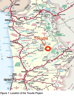
Toculla is located approximately 140 km northeast of Iquique in Region I of Chile. Total transit time from Iquique is 3.5 hours and access is gained through the village of Camiña which lies an hour’s drive southwest of Toculla. The project lies at an elevation of between 3,700 and 4,000 m above sea level.
Exploration Concessions – Toculla
The Toculla Gold Project initially covered 2,100 ha in 8 exploration concessions. New applications covering that ground and an additional 1,200 ha are now underway, taking the total area to 3,300 ha in 14 concessions.
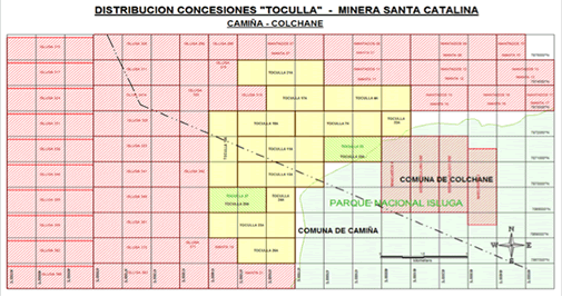
Figure 2: The Toculla Concessions.
The Toculla Gold Project
The geological setting of the region around Toculla consists of a series of Tertiary ignimbrites and andesitic–rhyolitic lavas (the “younger volcanics”) covering older volcano-sedimentary formations.
Catalina’s concessions at Toculla overlie the eastern part of an extensive area of the older volcano-sedimentary rocks exposed in a “window” where the otherwise ubiquitous cover of younger volcanics has been stripped away by erosion.
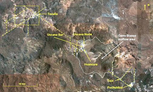
Figure 3: Structural Control on Hydrothermal Systems near Toculla.
The darker areas in Figure 3 are indicative of fresh, unaltered younger volcanics; the older volcano-sedimentary rocks are lighter in colour due to extensive hydrothermal alteration.
Toculla lies on a large regional-scale, NW-SE-trending structure (the Toculla-Puchuldiza Fault) which hosts active hydrothermal systems at Toculla, Uscana, Huancure, Tuja and Puchuldiza. The structure appears to exert a profound control on the geological setting of the Toculla concessions.
The gold-bearing Puchuldiza-Tuja geothermal system lies some 30-40 km to the southeast and hosts a “non-JORC” resource of circa 1 million oz. of gold and other precious metals in veins and stockworks developed in explosion breccias and silicified zones.
NW–SE structural trends such as the Toculla-Puchuldiza Fault are significant in both Argentina and Chile where prominent sets of similar lineaments strike across the Cordillera from east of the Puna in Argentina to the Chilean coast. Research suggests that repeated reactivation of these left-lateral strike-slip systems can create sites for mineral deposition.
At Toculla, there is evidence of two high-sulphidation (“HS”) epithermal complexes in the eastern and central part of the concession area.
Some 500 m to the north of these, an extensive, roughly east-west trending zone of silicification (Silica Ridge) is flanked by argillic alteration. It is over 1,100 m long and approximately 200 m wide (Figure 13). It lies on strike with several hot, hydrogen-sulphide emitting thermal springs and is intruded by a series of hydrothermal breccias.
The proximity of the HS systems and the hot spring–silicification zone raises the intriguing possibility of interaction between the two and the remobilisation and re-concentration of precious metal mineralisation – possibly associated with a series of younger hydrothermal breccias.
Samples from the hydrothermal breccias have returned low precious metal values consistent with those found in the upper levels of epithermal complexes. Arsenic and barium are anomalous; lead, antimony, tellurium, zinc and cadmium are elevated and molybdenum values are high. Mercury values are particularly high with a maximum value of 23 ppm
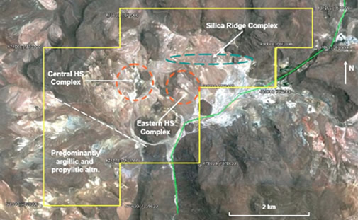
Figure 4: Geological Features of the Toculla Concessions.
Toculla presents a similar geological, stratigraphic and structural setting to that in which the gold-silver mineralisation has been developed at Puchuldiza-Tuja. Similar precious metal mineralisation may well have developed at Toculla.
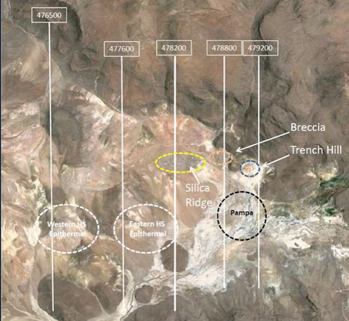
Figure 5: Exploration targets and geophysical survey lines at Toculla.
Some eight RC drillholes have been completed to unknown depths at some time in the past at Toculla. The holes intersected broad zones of anomalous gold pathfinder geochemistry but were sited without any modern, target definition geophysical survey. It is clear that no work has been undertaken locally for some years.
Argali was contracted to complete a reconnaissance induced polarisation (IP) survey at Toculla along five N-S trending lines (see Figure 5).
The primary objective of the geophysical survey was to help delineate deep zones of possible copper porphyry mineralisation and/or epithermal gold mineralisation and to provide data to assist in the mapping of various geological structures, zones of mineral alteration and differing lithologies.
Data were acquired with a pole-dipole array and a dipole spacing of 150 m expanded through eight separations (n= 1 to 8). Five lines totalling 17.4 km were surveyed on a line spacing varying from 500 to 1,000 m. These covered the main target areas delineated during previous exploration - Silica Ridge, the Breccia, Trench Hill, the Pampa area and the two HS Epithermal gold targets.
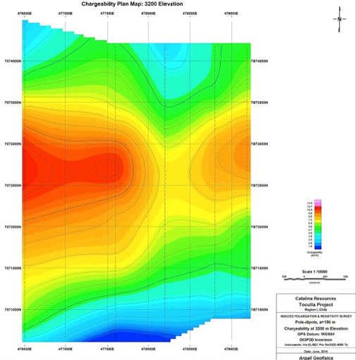
Figure 6: Chargeability at 3,200 m elevation.
The chargeability data from the IP survey outline a deep, weakly-chargeable, bimodal zone striking ENE beneath Silica Ridge, coincident with a weakly-resistive zone at depth. Figures 6 and 7 indicate that along the strike of Silica Ridge there is an inverse relationship between chargeability and silicification at surface. The lower chargeabilities underlie the areas of strongest silicification.
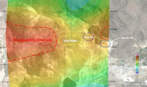
Figure 7: Chargeability data superimposed on the Google Earth image.
A possible explanation is that the silicification is related to a younger event which has destroyed or partially replaced older mineralisation reflected in the chargeability highs. The significance of this observation is that the majority of the previous drilling at Toculla on Silica Ridge was concentrated in the area with the greater silicification and lower chargeabilities. Consequently, the areas with the more anomalous chargeability remain untested at depth. More promising ground may lie to the west and east where the chargeability anomaly is more strongly developed.
It is not yet known why the chargeability widens to the west where it remains open. Hydrothermal alteration appears to extend at least 2 or 3 km west of the IP grid. Consequently, it is possible that the chargeability anomaly also extends a significant distance to the west. Additional IP lines are required to determine its full extent.
A second shallow, wide, comparatively high-amplitude (8-10 mV/V) chargeability anomaly occurs on the south end of the western Line 475600E in the south west of the survey area. This anomaly is associated with relatively high resistivities, seen elsewhere to be the response of younger post-alteration rocks; however, such rocks do not appear to be present at this location. Consequently, this anomaly appears to be produced by a combination of lithology and/or alteration that is not observed on the surface elsewhere within the IP grid.
This second anomaly also coincides with reports of anomalous Mo geochemistry. The resistivities and chargeabilities associated with this zone are similar to the deep resistive-chargeable zones identified in the main anomaly under Silica Ridge. Consequently, it is a possibility that both anomalous zones may be produced by similar lithology and alteration. Further fieldwork is planned for October 2014 to help determine its origin.